
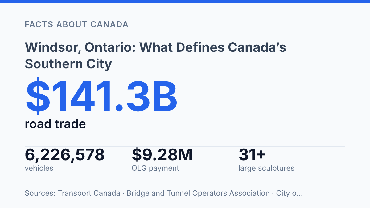
Windsor, Ontario, is defined less by latitude than by movement: in 2024, the Ambassador Bridge crossing handled CAD $141.276 billion in road trade with the United States, nearly one-quarter of Canada’s road trade at its busiest U.S. border crossings. That scale gives the city a role far larger than its population alone would suggest, linking local streets, riverfront land, customs infrastructure, tourism, and public memory to a continental economy.
The Detroit River is not just a boundary here; it is the organizing line for parks, monuments, sculpture, casino development, and one of North America’s most active trade corridors. Understanding the city means reading those layers together: the border infrastructure that moves goods, the waterfront spaces that shape civic identity, and the public institutions that turn a crossing point into a place.
Where Windsor sits and why its border location matters
Canada’s southern city faces north to the United States: Windsor is in Ontario, Canada, directly across the Detroit River from Detroit, Michigan. That close physical relationship makes the international boundary part of ordinary geography rather than a distant line on a map. Commuting, freight movement, tourism, family visits, and sports or entertainment trips all depend on the same cross-river connections, so local life is unusually tied to customs operations, bridge and tunnel capacity, and conditions on both sides of the border.
The economic scale of that position is measurable in national trade data. In 2024, the Windsor–Ambassador, Ontario crossing handled CAD $141.276 billion in road trade with the United States, equal to 24.9% of Canada’s road trade at the busiest U.S. border crossings and down 6.7% from 2023, according to Transport Canada. A single crossing accounting for roughly one-quarter of this measured road-trade category places the city among Canada’s most consequential border communities, not simply among its closest cities to the United States.
That status is strengthened by the broader local border network. As of 2026, Canada listed 118 land border ports of entry, with three in the local area: the Ambassador Bridge, the tunnel to Detroit, and the Gordie Howe International Bridge. The Canada Border Services Agency has said this corridor carries about 30% of Canada-U.S. trade by truck, worth more than $274 million per day.
The same features that create strong economic and cultural links also make movement more sensitive to rules and traffic conditions. Changes in inspection policy, construction, weather, labour disruptions, or congestion can affect far more than long-haul freight; they can alter daily travel patterns in a city whose nearest major neighbour is in another country.
What lines the waterfront from the Ambassador Bridge to the sculpture park
Few Canadian riverfront walks place a 1929 suspension bridge, large-scale public art, open lawns, and passing river traffic within one continuous civic corridor. The main waterfront park stretches about 5 kilometres, beginning near the Ambassador Bridge and running east along the Detroit River past the contemporary Windsor Sculpture Park. The result is not a detached greenbelt but a linear public edge shaped by both movement and pause.
The shoreline functions most clearly as a promenade. Paths, lookout points, grassed areas, and planted spaces keep the river visible for long stretches, while the opposite bank gives the walk a rare urban scale: the view is not only water, but another major skyline across it. According to municipal park information, the broader riverfront system is now described as more than six kilometres of greenspace, gardens, public art, monuments, and memorials, reflecting how the original uninterrupted stretch has been extended and connected over time.
Public art gives the western portion of the route a distinct identity rather than leaving it as a simple riverside path. The sculpture park includes more than 31 large-scale works along the Detroit River between the bridge area and Festival Plaza, according to municipal listings. Their placement makes the waterfront read as an outdoor gallery, but the setting keeps the works tied to everyday use: walking, cycling, sitting, watching boats, and moving between downtown destinations.
The corridor’s character depends on a visible contrast between leisure space and infrastructure. The Ambassador Bridge anchors one end with steel, traffic, and height, while the promenade below offers slower movement at ground level. This side-by-side arrangement helps explain why the riverfront feels civic rather than purely recreational: it presents the city’s working edge and its public face in the same view.
Dieppe Gardens, war memorials, and public remembrance
A riverside walk that otherwise emphasizes views, gardens, and public art is interrupted at Dieppe Gardens by a formal language of sacrifice and service. The park, listed at 70 Riverside Drive West, is named for members of the Essex-Kent Scottish Regiment killed in the 1942 Dieppe landing, according to the municipal parks listing, and it contains monuments dedicated to the Canadian Army, Navy, and Air Force. That placement gives the waterfront a commemorative role without turning it into a military site; remembrance is folded into ordinary public movement along the river.
The memorials function as civic markers because they are encountered in sequence with paths, seating areas, planted spaces, and open views across the water. In that setting, military memory is not separated from daily urban life. It sits within the same public route used for walking, gathering, and looking out over the river, which gives the site a quieter form of visibility than a stand-alone monument in a traffic circle or institutional forecourt.
Recent public-realm work shows that the commemorative purpose of the site is still being maintained rather than treated as a static inheritance. The city reported that work at the Dieppe Gardens memorial lookout area began on June 18, 2025, with completion expected by mid-August, including new LED lighting and a new concrete path around the Eternal Flame. Those upgrades are modest in scale, but they matter because accessibility, lighting, and path design shape how memorial spaces are used and respected.
The result is a shoreline with layered public meaning. The same corridor supports leisure, tourism, and civic ceremony, while Dieppe Gardens adds a reserved tone that links the riverfront to Canadian military remembrance and local identity.
Caesars Windsor and the city’s riverfront economy
Few Canadian casino hotels face a U.S. skyline as directly as Caesars Windsor, whose riverfront towers look toward downtown Detroit. The casino complex sits near the riverfront core rather than on an isolated highway site, which places it within the same visitor zone as hotels, restaurants, event venues, and civic attractions. That setting helps make the waterfront not only a public viewing and walking corridor, but also a commercial destination tied to overnight stays and entertainment spending.
The scale of the property explains why it carries economic weight beyond its gaming floor. Caesars Entertainment’s 2025 filing lists 101,600 square feet of casino space, 1,620 slot machines, 80 table games, and 760 hotel rooms and suites. Those figures show a venue built to attract multi-purpose visits: gaming, concerts, dining, conferences, and short hotel stays can be packaged into the same trip, which is especially useful in a border city where visitors may arrive for more than one reason.
Public finance data also shows the casino’s continuing local significance. In fiscal 2025–2026, the city received $9,284,338 from OLG for hosting the casino, and cumulative host-community payments since the property opened in May 1994 reached $140,630,268, according to municipal and OLG reporting. These payments do not capture the entire hospitality effect, but they provide a measurable indicator of how the casino is tied to local revenue as well as tourism branding.
The result is a riverfront identity shaped by two forces at once. Public gardens, memorials, paths, and views give the area its civic character, while the casino adds a recognizable commercial anchor that draws visitors after dark and outside the usual rhythm of parks and daytime sightseeing. Its cross-border appeal rests partly on that contrast: the city presents a Canadian waterfront facing an American downtown, with a major entertainment complex positioned to turn that geography into visitor traffic.
What the riverfront will have to carry next
The next measure of the city will not be trade volume alone. As the Gordie Howe International Bridge becomes part of a three-crossing corridor, public attention will likely shift toward how border capacity, waterfront access, and civic space coexist along the same narrow edge of the Detroit River.
That creates a practical test for local planning: economic infrastructure can dominate land, traffic, and policy, but the riverfront also carries memory, recreation, public art, and municipal revenue. The most revealing changes may be modest ones, such as improved paths, lighting around memorials, and decisions about how casino and border-related income is reinvested where residents and visitors actually meet the river.
Frequently Asked Questions
Q: Where is Windsor, Ontario located?
A: Windsor is in southwestern Ontario, directly across the Detroit River from Detroit, Michigan. Its position on the Canada–U.S. border has shaped the city’s transport links, economy, and daily cross-border movement.
Q: How long is Windsor’s waterfront park?
A: The main waterfront park stretches for about 5 kilometres. It runs from the 1929 Ambassador suspension bridge past Windsor Sculpture Park, making the riverfront one of the city’s defining public spaces.
Q: What can be seen along Windsor’s waterfront?
A: The waterfront includes Windsor Sculpture Park, Dieppe Gardens, and Caesars Windsor. Dieppe Gardens features monuments dedicated to the Canadian armed forces, while Caesars Windsor is a casino complex with views toward Detroit.
Q: Why is Windsor often associated with Detroit?
A: Windsor sits immediately across the river from Detroit, so the two cities are physically and economically connected. That proximity affects commuting, trade, and tourism, and it gives Windsor a cross-border identity uncommon among Canadian cities.
Q: Is Windsor known for more than its border location?
A: Yes. Its riverfront, public art, memorial spaces, and major entertainment venues give the city a distinct profile beyond geography. The waterfront in particular helps define Windsor as a city organized around its connection to the river and the border.