
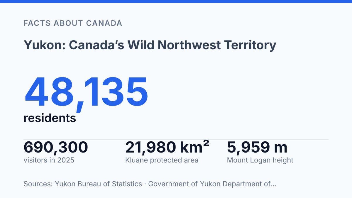
Yukon has fewer people than many Canadian suburbs: 48,135 residents spread across 474,391 km², with most clustered near Whitehorse. That works out to about 0.10 people per km².
The emptiness isn’t evenly shared, though. About 80.3% of the territory lives in the Whitehorse area.
In 2025, visitor estimates still reached 690,300, up 20.3% from the year before. That contrast is the hook. Huge country.
Thin roads. Serious parks. More travellers.
The real story sits in the pressure between access and scale. Kluane holds icefields, Mount Logan. A river corridor built for expeditions. Ivvavik protects Arctic ground that few people will ever reach.
The southern lakes offer an easier way in. They don’t soften the place much. In my honest opinion, the north here isn’t a backdrop. It sets the terms.
What makes Yukon so rugged and remote?
Yukon has less than one person for every ten square kilometres, so distance here isn’t a feeling. It’s the basic condition of travel. The territory covers Canada’s far northwest, pressed against Alaska, the Northwest Territories, British Columbia.
The Arctic edge. Roads reach the main communities, but huge stretches still read as mountain, boreal forest, tundra, river, and weather.
The numbers make the isolation plain. The 2021 Census counted 45,148 residents across a landmass larger than many countries.
A later territorial count put the population at 48,135 on December 31, 2025, spread across 474,391 km², with about 0.10 people per km². The Whitehorse area held 38,637 people, or about 80.3% of residents, according to the territorial 2026 Population Report Q4 2025 and fact sheet.
That concentration changes how the whole place works. The capital isn’t just an administrative centre.
It’s the main airport hub, service base, supply point, and place where many trips begin or end. Once you leave it, the gaps get wider fast.
The territory first hit the global imagination during the Klondike Gold Rush era of 1898, when stampeders treated the north as a shortcut to fortune. That old story still shapes the outside view. It can mislead you.
This isn’t a relic of frontier romance. It’s a modern northern territory where logistics, weather, and distance still set the rules.
The map can make the place look empty. That emptiness is the source of both its pull and its difficulty. You get silence, scale, dark skies.
A rare sense of space. You also get long drives, limited services, sudden weather, and real consequences when plans go wrong. In my view, that tradeoff is exactly what makes the territory feel honest rather than merely scenic.
Why Kluane National Park draws the biggest attention
More than 80% of Kluane is icefield and glacier, so its most famous wilderness is mostly a place visitors look toward rather than enter. That single fact explains the park’s pull better than any brochure language. It promises scale first, access second.
The park was established in 1972, and Parks Canada lists its protected area at 21,980 km², close enough to call it 22,000 square kilometres without exaggeration. That size matters. It means Kluane can absorb roads, air tours, river trips, and backcountry travel without feeling even remotely crowded.
Above all of it stands Mount Logan, Canada’s highest mountain at 5,959 metres. It gives the park a clear symbol.
The peak is not a casual prize on the horizon. Its presence is more like a warning label: this is alpine country built on weather, ice, distance, and patience.
The harder truth is that fame doesn’t translate into full experience. Parks Canada recorded 48,472 visits in fiscal 2024–25, which works out to about 2.2 visits per square kilometre. That sounds generous until you remember most people cluster near the accessible edges, leaving the interior almost untouched by ordinary travel.
The Alsek River adds another kind of scale. A 90-km section inside Kluane became a Canadian Heritage River in 1986.
The wider river runs about 250 km from the Dezadeash–Kaskawulsh confluence to the Gulf of Alaska. It turns the park from a mountain showcase into a moving corridor of ice, water, and expedition history.
That contrast is the reason Kluane gets the biggest attention. It’s famous enough to anchor the territory’s protected-area identity, but wild enough that most visitors leave with only a fragment. In my honest opinion, that incompleteness is exactly why Kluane matters: it resists being reduced to a lookout stop.
How Ivvavik protects caribou and Arctic country
A park can be almost empty of visitors and still carry the weight of a 250,000 km² migration route. That’s the scale Parks Canada uses for the range of the Porcupine caribou herd, which moves across northern Alaska, northern Canada.
The Northwest Territories. Ivvavik protects part of the calving and post-calving habitat that gives that journey its purpose.
Created in 1984, Ivvavik National Park was never just a scenic reserve on a map. Its name means “a place for giving birth” in Inuvialuktun.
That matters. The park’s identity is tied to renewal, not postcard views. In my humble opinion, that makes its protection feel more urgent than many places with louder travel reputations.
The hard truth is simple: this park’s value isn’t only that it’s wild. It’s that one herd depends on the ground staying quiet at the right time of year.
Calving areas don’t need crowds, roads, or noise. They need space, timing, and restraint.
That restraint comes with a tradeoff. Ivvavik is difficult and costly to reach, with access typically by aircraft rather than road. Parks Canada attendance data recorded just 145 visits in fiscal 2024–25, a number so small it makes the park feel almost theoretical to most travelers.
But low visitation isn’t failure here. It’s part of the design.
This is Arctic protection at its most practical. The park guards tundra, river valleys, and coastal plain habitat as working ecological space.
You don’t protect a migration by saving one pretty viewpoint. You protect the places where birth, feeding, and movement still happen without interference.
Which lakes and smaller sights make the south memorable?
The roadside view of Emerald Lake looks almost artificial, yet its color comes from a harsh mix of cold water, suspended minerals, and light. That’s the trick of the southern lake country.
It feels easy to reach. The chemistry comes from the same glacial forces that make the region hard, cold, and unforgiving.
Access changed in 1974, when the South Klondike Highway opened and made this corridor far less isolated than it had been. The road didn’t tame the country. It just let more people stand at the edge of it and realize how quickly pavement gives way to rock, wind, and water.
Nearby Carcross gives the area its clearest anchor. It’s not just a place to pass through for a lake photo.
The community sits near Bennett Lake and Tagish Lake, tying together Indigenous history, railway-era traces. The modern road corridor without turning the place into a polished resort strip.
The smaller sights matter because they sharpen the contrast. Territorial tourism pages describe the Tagish River as part of a 600-km interconnected network of lakes, a scale that turns a “scenic stop” into one piece of a much larger water system.
You see a pullout. The map shows a chain.
Carcross Desert adds another twist. Its 2.6 km² of sand is promoted as the world’s smallest desert.
The label is more catchy than precise. The dunes are a remnant of older glacial lake sediments, not a hot-climate desert in the usual sense. In my view, that mismatch makes it more interesting, not less.
The south stays memorable because it compresses the territory’s drama into reachable fragments. A colored lake, a small community, a windy patch of sand.
A highway through mountain country can say as much as a famous wilderness area. You don’t need a grand expedition to feel the edge here.
Why the empty miles matter more than the map pins
A Yukon trip rewards restraint more than ambition. You can chase a map full of names. The smarter move is to choose fewer places and give them room.
The next shift will test that discipline. 690,300 visitors came in 2025, yet Ivvavik saw only 145 park visits in the fiscal year. That gap is not a marketing problem. It’s a reminder that access has consequences, and distance still protects what popularity can damage.
In my humble opinion, the best travel here starts when you stop treating distance as wasted time. Plan for weather, silence, and gaps in service.
The empty spaces are not between the sights. They are the point.
Frequently Asked Questions
Q: What is Yukon best known for?
A: Yukon is best known for wild mountain scenery and very low population density. It’s not a place built around big cities. That’s the appeal. What stands out most is the scale of the land, plus the quiet that comes with it.
Q: What is the highest peak in Yukon?
A: Mount Logan is the highest peak in Canada. It sits in Kluane National Park and Reserve. That makes the park a major draw for hikers, climbers, and anyone who wants serious alpine terrain. The mountain dominates the area… and it does so with real presence.
Q: What can you do in Kluane National Park and Reserve?
A: You can hike trails, see glaciers, and follow the Alsek River through dramatic terrain. The park gives you classic northern scenery without trying to soften it. In my view, that rawness is exactly why people remember it.
Q: Why is Ivvavik National Park important?
A: Ivvavik National Park protects calving grounds for Porcupine caribou in the far north. That makes it more than a scenic stop. It’s a place tied to wildlife survival. The tension here is simple: the park looks remote, but its role is very specific and vital.
Q: Are there lakes to see in Yukon?
A: Yes, the south has numerous glacier-fed alpine lakes, including Emerald Lake. The color can be startling, and that’s the point. You get calm water. The setting still feels severe and untouched.