
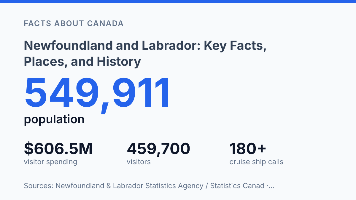
Newfoundland and Labrador had an estimated 549,911 people in 2025, but its story refuses the usual Canadian pattern: only 44.3% lived in a census metropolitan area, compared with 74.8% nationally. That contrast explains a lot. The province feels less like one centre with a fringe and more like a chain of hard-won settlements facing rock, ocean, weather, and distance.
The deeper surprise sits much earlier. At L’Anse aux Meadows, wood samples place Norse activity in AD 1021, a precise year that pulls North American history out of abstraction. Then the land itself raises the stakes.
Gros Morne exposes the mechanics of continents. St. John’s turns a harbour into a lookout over war, trade, and signal fires. In my honest opinion, the province matters because it makes geography feel like evidence, not backdrop.
Canada’s eastern edge: what makes the province different
Canada reaches farther east here than most visitors realize: the province stretches across Newfoundland island and the mainland region of Labrador, with the Atlantic setting the terms. That geography gives it a different feel from provinces tied more closely to central Canadian highways, rail corridors, and border cities.
You don’t just pass through on the way to somewhere else. You make a decision to go there.
Since joining Confederation in 1949, the single province has carried the official name Newfoundland and Labrador. The name matters. It keeps two linked but distinct places in view: the island in the North Atlantic and Labrador on the mainland, facing Quebec to the west and cold ocean routes to the east and north.
Distance shapes daily life here in practical ways. Flights matter. Ferries matter.
Weather can reset a plan fast, especially when fog, wind, ice, or rough seas move in from the Atlantic. That can make the province feel remote on a map. The same edge position gives it a sharper identity than places built around easy access.
The population also tells that story. On July 1, 2025, the province’s population was estimated at 549,911, with 243,478 people in the St. John’s census metropolitan area, according to Newfoundland & Labrador Statistics Agency / Statistics Canada.
So the capital region carries real weight. The province isn’t just one urban centre with empty space around it.
In my view, the most interesting thing about this province is that its distance isn’t a weakness. It explains the place.
The ocean-facing edge has shaped settlement, travel, speech, work, and memory in ways that still show up when you move between communities. Canada feels wider from here… and older, too.
L’Anse aux Meadows and the Viking footprint
A few low turf outlines at L’Anse aux Meadows carry more historical weight than most castles. On the northern tip of Newfoundland island, the site ties a real place to the Norse voyages linked with Leif Erikson, turning saga material into something you can measure in postholes, iron scraps, and sod walls.
The story sounds legendary. The archaeology is stricter than the myth… and that’s what makes it stronger.
Parks Canada and UNESCO don’t need a horned-helmet fantasy here. They point to a working settlement, not a grand colony, with evidence of repair, carpentry, boat work, and short-term occupation around 1000 CE.
UNESCO inscribed L’Anse aux Meadows as a World Heritage Site in 1978 and identifies it as the only confirmed Norse site in North America. That single status matters.
It places Newfoundland and Labrador inside the history of early transatlantic contact centuries before Columbus. It does so through physical remains rather than patriotic exaggeration.
The remains are modest on purpose. UNESCO describes eight timber-framed turf structures at the site, spread across a protected area of 7,991 hectares.
That scale doesn’t suggest a large permanent town. It suggests a base: useful, temporary, and connected to wider movement across the North Atlantic.
A sharper detail came from later science. A 2021 Nature study, summarized by NASA Earth Observatory, dated three wood samples from the site to trees cut in AD 1021.
That doesn’t replace the broader around-1000 timeline. It tightens it, giving the Norse footprint a precise mark on the calendar.
In my honest opinion, the power of L’Anse aux Meadows is that it refuses to overperform. It’s not dramatic in the way ruins usually sell themselves, but its restraint is exactly why it matters: the ground says just enough, and no more.
Gros Morne’s cliffs, fjords, and glacier-shaped terrain
A walk through the Tablelands puts orange-brown mantle rock under your boots, material that normally sits far below the ocean floor. That’s the twist at Gros Morne National Park: it looks like a classic coastal park, but its real draw is geological evidence you can walk beside.
Set on the Gulf of St. Lawrence, the park carries the visual drama people expect from western Newfoundland: sea-facing cliffs, high waterfalls, and glacial fjords cut deep into old rock. Parks Canada says Western Brook Pond runs 16 km long and reaches 165 m in depth. Its cliffs rise up to 680 m, with Pissing Mare Falls dropping about 350 m from the plateau above.
UNESCO inscribed the park in 1987. The reason wasn’t just scenery. The World Heritage Centre lists it as a 180,500-hectare property that helps explain continental drift and ancient mountain-building along eastern North America.
That matters. Gros Morne turns plate tectonics from a textbook diagram into something physical and exposed.
The Tablelands make the case in the bluntest way. This is exposed mantle rock, pushed upward during the collision of ancient tectonic plates.
In most places, that material stays buried beyond reach. Here, it sits in a national park, bare and rust-coloured, with sparse plant life that makes the ground look almost misplaced.
That contrast gives the park its force. You can come for cliffs and fjords.
You leave understanding why geologists treat the area as evidence, not decoration. In my humble opinion, the Tablelands are the part that makes Gros Morne more than beautiful. They make it intellectually hard to forget.
St. John’s, Signal Hill, and the city above the harbour
St. John’s doesn’t sprawl so much as climb. That vertical pressure gives the capital a sharper profile than many cities several times its size.
As the southeastern capital of the province, it sits tight against a working harbour, with streets rising from the waterfront toward ridges and lookout points. The result is a city that can look compact and historic from a map, but feel much more dramatic underfoot.
The harbour explains the shape of the place. Buildings crowd the slopes above the water. The entrance from the Atlantic is guarded by high ground on both sides. Signal Hill is the key height.
Its 17th-century citadel and later fortifications turned that ridge into a defensive post for ships, soldiers. A city that depended on the harbour staying open.
Defense wasn’t the hill’s only job. Signal Hill also became part of the city’s communication history, first through visual signals sent to vessels offshore and later through wireless transmission. In 1901, Guglielmo Marconi received the first transatlantic wireless signal there, linking the site to a new kind of Atlantic crossing: not by ship, but by message.
The walk up the hill still makes that history feel physical. The trail is not just a pleasant overlook. It’s a steep route through exposed rock, wind, and sudden drops toward the Narrows.
At about 167 metres above sea level, the summit gives you a hard, clean view over St. John’s, the harbour. The open Atlantic beyond it.
In my view, the best thing about this part of the city is that the view doesn’t flatten the history. You can see why the harbour mattered, why the hill was defended, and why a small-looking capital can leave a much larger impression than expected.
What the map teaches better than the guidebook
The smartest way to read this province is by scale, not speed. Gros Morne can turn one drive into a geology lesson. The better lesson is practical: weather, distance, and ferry schedules decide what you actually get to see.
That matters more as travel grows. In 2025, the province counted more than 180 cruise ship calls across 24 ports. The old image of a hard-to-reach edge is already out of date.
More visitors will find the famous places. The reward will go to travellers who leave room for the smaller harbours, roadside pull-offs, and long gaps between towns. In my humble opinion, the silence between the landmarks is part of the province’s evidence, not empty space.
Frequently Asked Questions
Q: What is Newfoundland and Labrador known for?
A: It’s Canada’s most easterly province. That geography shapes a lot of its identity. People also know it for L’Anse aux Meadows, Gros Morne National Park, and St. John’s Signal Hill. In my view, that mix of deep history and raw coastline is the province’s real draw.
Q: Is L’Anse aux Meadows the same place as Viking Newfoundland?
A: Yes, that’s the site people mean when they talk about Viking history in the province. L’Anse aux Meadows on Newfoundland island is the Norse archaeological site linked to Leif Erikson. It matters because it’s one of the clearest traces of early European presence in North America.
Q: What can you see at Gros Morne National Park?
A: You get cliffs, waterfalls, and glacial fjords in one park. Gros Morne sits on the Gulf of St Lawrence. The scenery feels dramatic without feeling overbuilt. The contrast is the point… it looks wild, but it’s also a carefully protected place.
Q: Why is St. John’s important in Newfoundland and Labrador?
A: St. John’s is the provincial capital. It sits in the southeast of the island. Signal Hill is the headline attraction there, with its 17th-century citadel and hillside walking trail. That mix of city life and old fortifications gives the place a sharper edge than most visitors expect.
Q: What’s the best way to think about the province’s history?
A: Start with place, not dates. The story runs from the Norse site at L’Anse aux Meadows to coastal settlements and the capital’s military past. That spread matters. In my honest opinion, the best history here isn’t locked in a museum. You can still walk past it.